EFTF - Exploring For The Future
Type of resources
Keywords
Publication year
Topics
-
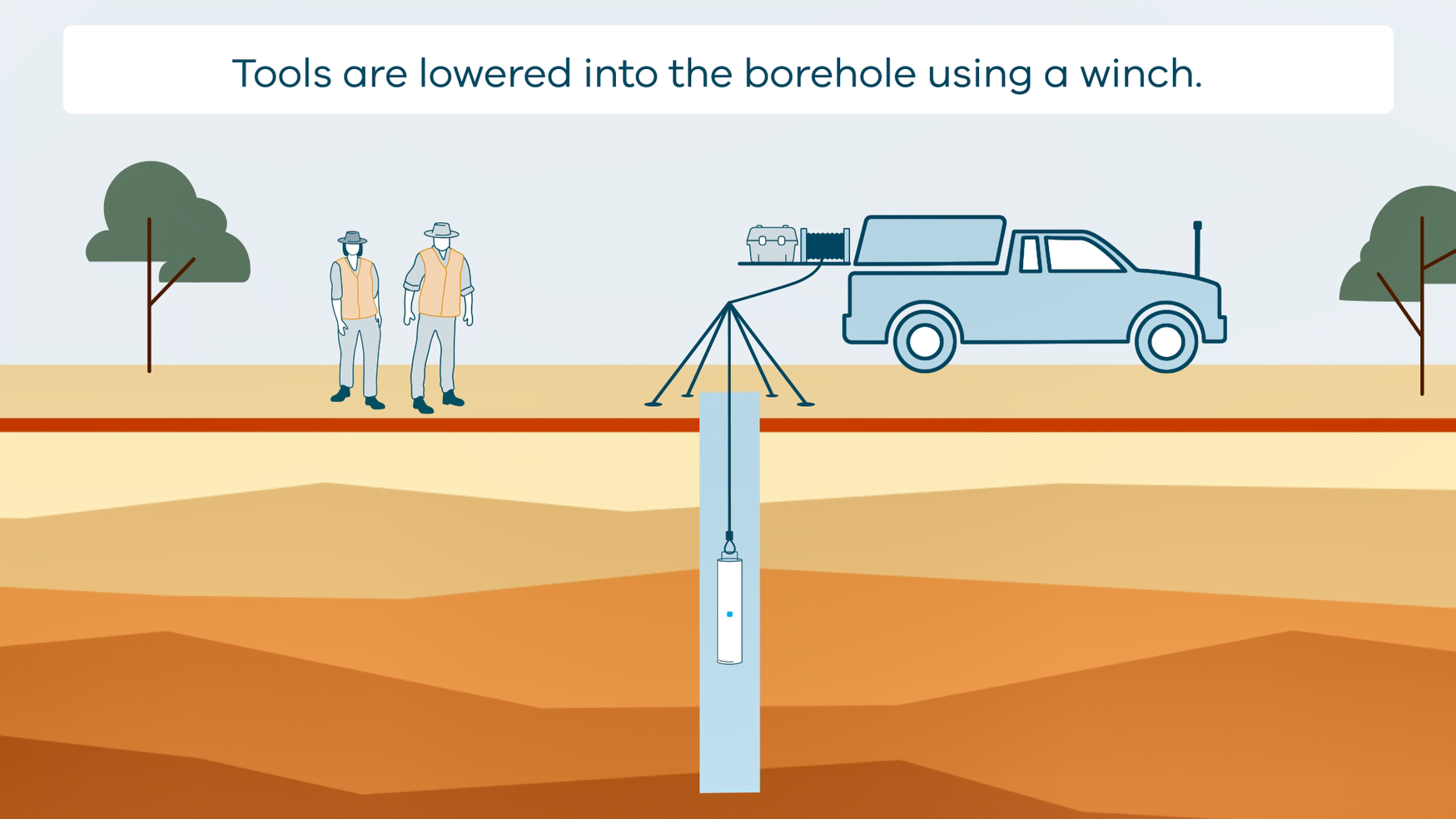
This animation shows how borehole geophysical surveys are conducted. It is part of a series of Field Activity Technique Engagement Animations. The target audience are the communities that are impacted by GA's data acquisition activities. There is no sound or voice over. The 2D animation includes a simplified view of what borehole geophysics equipment looks like, what the equipment measures and how scientists use the data.
-
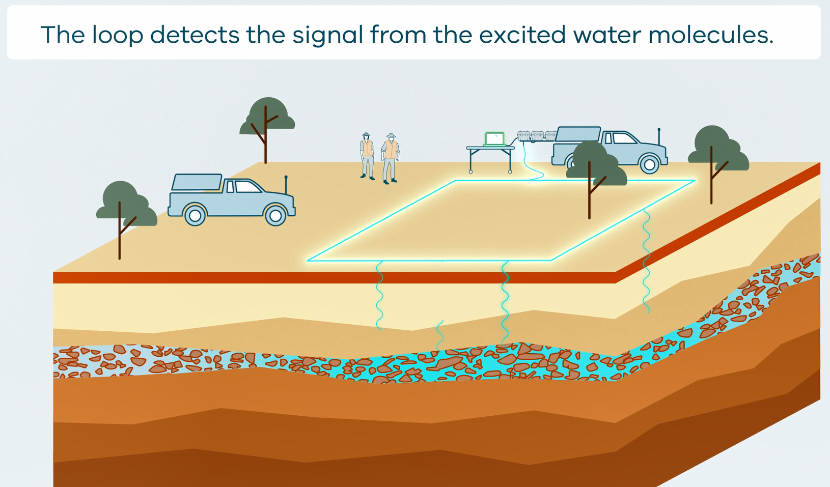
This animation shows how Surface Magnetic Resonance (SMR) Surveys are conducted. It is part of a series of Field Activity Technique Engagement Animations. The target audience are the communities that are impacted by GA's data acquisition activities. There is no sound or voice over. The 2D animation includes a simplified view of what SMR equipment looks like, what the equipment measures and how scientists use the data.
-
Mineral exploration in Australia faces the challenge of declining discovery rates despite continued exploration investment. The UNCOVER roadmap, developed by stakeholders from industry, government and academia, has highlighted the need for discovering mineral resources in areas of cover. In these areas, potentially prospective basement is covered by regolith, including transported sediment, challenging many traditional exploration methods designed to probe outcrop or shallow subcrop. Groundwater-mineral interaction in the subsurface has the potential to give the water geochemical and isotopic characteristics that may persist over time and space. Geoscience Australia’s hydrogeochemistry for mineral exploration project, part of the Exploring for the Future Programme, aims to use groundwater chemistry to better understand the bedrock-regolith system and develop new methods for recognising mineral system footprints within and below cover. During the 2017 dry season (May to September), ~150 groundwater samples (including QC samples) were collected from pastoral and water supply bores in the regions of Tennant Creek and McArthur River, Northern Territory. The Tennant Creek region has a demonstrated iron oxide-hosted copper-gold-iron(-bismuth) mineral potential in the Paleoproterozoic and Mesoproterozoic basement and vast areas of regolith cover. Among the critical elements of this mineral system, the presence/absence of redox contrasts, iron enrichment, presence of sulfide minerals, and carbonaceous intervals can potentially be diagnosed by the elemental and isotopic composition of groundwater. The McArthur River region, in contrast, has demonstrated sediment-hosted stratiform lead-zinc-silver mineral potential in the Paleoproterozoic to Neoproterozoic basement and also vast areas of regolith cover. Here, critical mineral system elements that have the potential to be identified using groundwater geochemistry include the presence of felsic rocks (lead source), carbonate rocks (zinc source), basinal brines, dolomitic black shales (traps), and evaporite-rich sequences. Preliminary results will be presented and interpreted in the context of these mineral systems.
-
The Officer Basin in South Australia and Western Australia is the focus of a regional stratigraphic study being undertaken by the Exploring for the Future (EFTF) program, an Australian Government initiative dedicated to increasing investment in resource exploration in Australia. This data release provides new data and discusses the results from a new commissioned petrographic study of rock samples from five wells of the Officer Basin including: GSWA Vines 1, Yowalga 3, Birksgate 1, Giles 1, and Munta 1. Data includes petrography, XRD, thin section scans and photos, as well as petrographic summaries
-
Stratigraphic drill hole NDI Carrara 1 was drilled as a collaboration between Geoscience Australia (GA), the Northern Territory Geological Survey (NTGS) and the Mineral Exploration Cooperative Research Centre (MinEx CRC). It reached a total depth of 1751 m in late 2020 and is the first drill hole to intersect the undifferentiated Proterozoic rocks of the Carrara Sub-Basin. It intersected approximately 630 m of Cambrian Georgina Basin sedimentary rocks overlying the ~1100 m of Proterozoic carbonates, black shales and other siliciclastics of the Carrara Sub-Basin succession. The formational assignments of the Georgina Basin succession are preliminary and were assigned in the field. The units intersected comprise the Border Waterhole Formation (~531m to ~630m), which is overlain by the Currant Bush Limestone (~249m to ~531m), which in turn is overlain by the Camooweal Dolostone (0m to ~249m). Of these, only the lower 80% of the Currant Bush Limestone and the entire Border Waterhole Formation were cored. This report presents biostratigraphic results from macrofossil examination of NDI Carrara 1 core samples within the Georgina Basin section.
-
This animation shows how Reflection Seismic Surveys Work. It is part of a series of Field Activity Technique Engagement Animations. The target audience are the communities that are impacted by our data acquisition activities. There is no sound or voice over. The 2D animation includes a simplified view of what reflection seismic survey equipment looks like, what the equipment measures and how the survey works.
-
This animation shows how passive seismic surveys Work. It is part of a series of Field Activity Technique Engagement Animations. The target audience are the communities that are impacted by our data acquisition activities. There is no sound or voice over. The 2D animation includes a simplified view of what passive seismic equipment looks like, what the equipment measures and how the survey works.
-
This animation shows how Airborne Electromagnetic Surveys Work. It is part of a series of Field Activity Technique Engagement Animations. The target audience are the communities that are impacted by our data acquisition activities. There is no sound or voice over. The 2D animations include a simplified view of what AEM equipment looks like, what the equipment measures and how the survey works.
-
Geoscience Australia’s Exploring for the Future program (EFTF) provides precompetitive information to inform decision-making by government, community and industry on the sustainable development of Australia's mineral, energy and groundwater resources. The Australian Passive Seismic Array Project (AusArray) program developed from a long history of passive seismic imaging in Australia involving many contributors. Building on this history, the Australian Government (EFTF), academia and state governments have united around AusArray. The objective is a standardised and quality controlled national passive seismic data coverage and an updatable national seismic velocity model framework that can be used as a background for higher-resolution studies. The AusArray passive seismic data are supplemented with active seismic data that can provide P-wave and S-wave velocity information for the near surface down to about 50 m depth. This near-surface velocity data will provide constraints for some AusArray passive seismic data modelling to obtain more reliable depth models. This document details the active seismic data acquisition using TROMINO® three-axis broadband seismometers using a wireless trigger and hammer source. Equipment packing, field operations, data extraction and preparation, and Multichannel Analysis of Surface Waves (MASW) modelling are described.
-
This Record documents the efforts of Mineral Resources Tasmania (MRT) and Geoscience Australia (GA) in compiling a geochronology (age) compilation for Tasmania, describing both the dataset itself and the process by which it is incorporated into the continental-scale Isotopic Atlas of Australia. The Isotopic Atlas draws together age and isotopic data from across the country and provides visualisations and tools to enable non-experts to extract maximum value from these datasets. Data is added to the Isotopic Atlas in a staged approach with priorities determined by GA- and partner-driven focus regions and research questions. This Tasmanian compilation represents the second in a series of compilation publications (Records and Datasets) for the southern states of Australia, which are a foundation for the second phase of the Exploring for the Future initiative over 2020–2024. It was compiled primarily from data, reports, journal articles and theses provided to GA by MRT. The most current data can be accessed and downloaded from GA’s <a href=https://portal.ga.gov.au/persona/geochronology>EFTF Geochronology and Isotopes Data Portal</a> and MRT’s <a href=https://www.mrt.tas.gov.au/mrt_maps/app/list/map>LISTmap.</a>